
Looking for your ancestors from the Netherlands? Yvette Hoitink is a professional genealogist in the Netherlands who does research throughout the country. Read about our services, fees, and example projects or read testimonials by clients like you.
If you want to learn more about researching Dutch ancestors, make sure to read the blog.
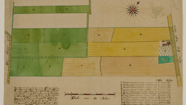
Map of the week: Slangenrode farm near Utrecht
This map shows the Slangenrode farm with its meadows (green) and farmland (green). The farm was located in the Lageweide area between the Huppeldijk and Lageweidsdijk in Utrecht. The map dates from 1718. Although the catalog description does not tell us the purpose of the map, such maps are often created during court cases, for […]
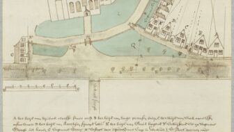
Map of the Week – Bodegraven around the church, 1664
Sometimes, maps are created in civil lawsuits, for example in boundary disputes. I love these maps for the details they provide, not just about the location but about the people in the community. This week we are looking at a map of Bodegraven that shows the houses around the church in 1664. The map was […]
Dutch Genealogy News for April 2024
Here is an overview of the new sources, projects, and other news from the past month. Sources The stories of 2100 Engelandvaarders [England sailors] are now available at the National Archives website. Engelandvaarders were Dutch citizens who went to the United Kingdom during World War II, where they were debriefed by British and Dutch security services. The interrogation […]
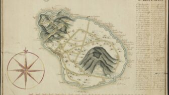
Map of the Week – Map of St. Eustatius, early 1700s
Saint Eustatius in the West Indies is one of the Netherlands Antilles. In the 1700s, it was a colony of the Netherlands. This manuscript maps shows the island in the early 1700s and marks all the plantation owners on the map. The archival description says this map dates from the 18th century. Based on research […]
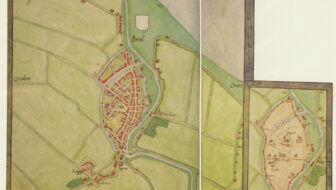
Map of the Week: Brielle circa 1566
Around 1566, Jacobus van Deventer was charged by the King of Spain and ruler of the Habsburg empire that included the Netherlands to create maps of all the major cities in the country. This was shortly before the outbreak of the Eighty Years War, which started when several noblemen abjured the King as their overlord […]
Quick tip – Who was your ancestor the guardian for?
I have written before about using guardianship records for genealogical research. Most often, we use these records to find out who became the guardian over minor children after our ancestors died. Less often, we will check those records to see for whom our ancestors were guardians. Since guardians were often close relatives, this can be […]
Dutch term – Gepasporteerd
Gepasporteerd (literally: passported) means a passport was issued. You will typically come across the term in military service records in the 1800s. At the end of service, a soldier received a passport to show he fulfilled his military duties. Since these passports were given to the soldiers, they may have survived in private collections but […]

")