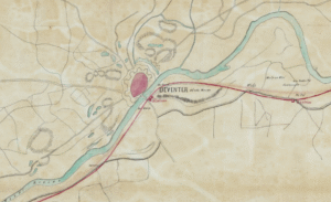
This week we are looking at a map planning the railroad from Arnhem to Zwolle in 1857. The map shows the planned trajectory and stations. This map can be found in record group 4.WCA at the National Archives, which holds the records for the Department of Public Works and its predecessors 1814-1940. The record group has maps of public works like roads, railroads, dikes, mines, airports, etc. The arrival of a railroad in a town could have affected our ancestors' lives in different … [Read more...]
Map of the Week – Connections in Utrecht, circa 1919
14 October 2024 by Leave a Comment

This map, created shortly after the end of World War I, shows the different connections in the province of Utrecht The legend identifies the different types of lines on the map: railroads tramways paved roads gravel roads provincial border dikes hills. The 1800s saw a tremendous increase in infrastructure. This map captures the rail and tram infrastructure at its height. In the course of the 1900s, many rail and tram lines were abolished as cars and transport by road … [Read more...]

")