
This week we are looking at one map from an atlas of properties in the county of Bergh in Gelderland from 1727. The whole atlas is available at the website of the Erfgoedcentrum Achterhoek en Liemers. Such atlases often show the plots, which can help us locate our ancestor's properties. Sometimes, the names of the owners or tenants are indicated on the map. … [Read more...]
Map of the week – Border between Rijnland, Utrecht, Amstelland, 1567
8 September 2025 by Leave a Comment
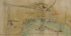
This week we are looking at a map showing the border between Rijnland, Utrecht, and Amstelland in 1567. It was a copy from The map is oriented with the north toward the left. Most of the map shows the border between Rijnland (in green) and the Sticht Utrecht (in yellow). These areas all had their own water boards, managing the dikes in their respective areas. The map shows the towns along the border, and indicates which polders belonged to which jurisdiction. Maps like this can help … [Read more...]
Map of the Week – Railroad Arnhem-Zwolle, 1857
1 September 2025 by Leave a Comment
This week we are looking at a map planning the railroad from Arnhem to Zwolle in 1857. The map shows the planned trajectory and stations. This map can be found in record group 4.WCA at the National Archives, which holds the records for the Department of Public Works and its predecessors 1814-1940. The record group has maps of public works like roads, railroads, dikes, mines, airports, etc. The arrival of a railroad in a town could have affected our ancestors' lives in different … [Read more...]
Map of the Week – Local Militias, 1887
28 July 2025 by Leave a Comment

This 1887 map shows the local militias ("schutterijen") for each municipality. Local militias were responsible for the defense of the municipality in case of trouble. Larger municipalities, marked with diagonal red hatching, had active local militias. The men serving in these militias would get regular training and exercises and could be called up at any time to help keep order. Other municipalities had inactive or resting militias. These men were reserves. They could be called up in … [Read more...]
Map of the Week – Utrecht, 1659
21 July 2025 by Leave a Comment

In 1659, the famous mapmaker Joan Blaeu published his world atlas Tooneel des Aardrycks [Display of the Realm of Earth]. The archives in Leiden have made their atlas available online. This week we are looking at Blaeu's map of the province of Utrecht. The map shows that its largest city was the same-named Utrecht. The map shows a great difference in geography in the east and west of the province. The east is higher, with more woods. The lower land in the west has been drained and turned into … [Read more...]
Map of the week – Confiscated lands in Zutphen, 1573
14 July 2025 by Leave a Comment

This week we are looking at a map showing confiscated lands in Zutphen in 1573. This map was created during the Eighty Years War, when the Netherlands fought to become independent from the Habsburg Empire, ruled by King Philip II of Spain. In 1572, Zutphen was besieged and conquered by Dutch troops, and then by the Spanish. The Spanish seized all the assets of the town, which included several pieces of land in the area. The map shown above shows the location of six pieces of land just … [Read more...]
Map of the week – Land of Daniel Pichot in Suriname
7 July 2025 by Leave a Comment

This 1719 map shows land owned by Daniel Pichot at the Paulus creek in Suriname. The map shows the location of a piece of land, large 1000 acres, at the Paulus creek, a tributary of the Suriname river. The land was surveyed on 25 November 1719 and the map was finished on 13 December 1719. The map showed the three places where the creek entered Pichot's land, ending in a largee swamp. An "Indiaans Dorp" [Native American village" was located on the south-east of the property. The … [Read more...]
Map of the Week – River Meuse near Heusden, 1877
30 June 2025 by Leave a Comment

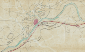
This week we are looking at the Topographic-Military Map of 1877, showing the area around Heusden. The map shows traces of the former runs of the river Meuse ("Maas" in Dutch) that meandered through the landscape. Heusden used to be on one bend of the river, before the river found a new course further north. It left behind a part of the bend, called "Doode Maas" [dead Meuse] on the map. If we study the map, we can see several traces of former river bends in the landscape. The changing … [Read more...]
Map of the Week – Overseas Territories, Early 1800s
2 June 2025 by Leave a Comment
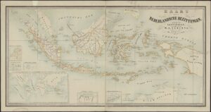
This week we are looking at an undated map from the early 1800s, showing all the overseas possessions claimed by the Netherlands at the time. Click the map to go to the full-size version at the website of the Nationaal Archief. The Dutch East Indies (present-day Indonesia) formed the majority of the Dutch overseas possessions, outlined by ochre yellow. The Netherlands also claimed six islands in the West Indies, land between the Corantijn and Marowijne rivers in South America (present-day … [Read more...]
Map of the Week – Gelderland, 1659
19 May 2025 by Leave a Comment
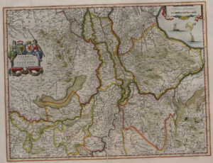
In 1659, the famous mapmaker Joan Blaeu published his world atlas Tooneel des Aardrycks [Display of the Realm of Earth]. The archives in Leiden have made their atlas available online. This week we are looking at Blaeu's map of Gelderland, oriented with the north towards the right. We can see the major rivers Rhine [Rijn in Dutch, "Rhenus fluvius" on the map], Meuse [Maas in Dutch, "Mase fluvius" on the map], Waal ["Waal flu."], and IJssel ["Yssel flu." ]. Most of Gelderland's most prosperous … [Read more...]

")