
In 1659, the famous mapmaker Joan Blaeu published his world atlas Tooneel des Aardrycks [Display of the Realm of Earth]. The archives in Leiden have made their atlas available online. This week we are looking at Blaeu's map of the province of Utrecht. The map shows that its largest city was the same-named Utrecht. The map shows a great difference in geography in the east and west of the province. The east is higher, with more woods. The lower land in the west has been drained and turned into … [Read more...]
Map of the Week – Gelderland, 1659
19 May 2025 by Leave a Comment
In 1659, the famous mapmaker Joan Blaeu published his world atlas Tooneel des Aardrycks [Display of the Realm of Earth]. The archives in Leiden have made their atlas available online. This week we are looking at Blaeu's map of Gelderland, oriented with the north towards the right. We can see the major rivers Rhine [Rijn in Dutch, "Rhenus fluvius" on the map], Meuse [Maas in Dutch, "Mase fluvius" on the map], Waal ["Waal flu."], and IJssel ["Yssel flu." ]. Most of Gelderland's most prosperous … [Read more...]
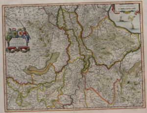
Map of the Week – Limburg, 1659
10 March 2025 by Leave a Comment

In 1659, the famous mapmaker Joan Blaeu published his world atlas Tooneel des Aardrycks [Display of the Realm of Earth]. The archives in Leiden have made their atlas available online. This week we are looking at Blaeu's map of the Duchy of Limburg. In the east, we can see the river Meuse [Maas in Dutch, "Mosa Fluvius" on the map] connecting the cities of Maastricht ("Maestricht") and Luik ("Luyck vel Liege"). Limburg is in the higher part of the Netherlands, so we see more woods and hills, … [Read more...]
Map of the Week – Groningen, 1659
3 February 2025 by Leave a Comment

In 1659, the famous mapmaker Joan Blaeu published his world atlas Tooneel des Aardrycks [Display of the Realm of Earth]. The archives in Leiden have made their atlas available online. This week we are looking at Blaeu's map of the province of Groningen. It shows its largest city as the same-named Groningen ("Gronningen" on the map), connected to the North Sea by the Reitdiep. The map shows the roads and rivers that connected the smaller towns. See the research guide for Groningen for more … [Read more...]
Map of the Week – Brabant, 1659
9 December 2024 by Leave a Comment

In 1659, the famous mapmaker Joan Blaeu published his world atlas Tooneel des Aardrycks [Display of the Realm of Earth]. The archives in Leiden have made their atlas available online. This map shows the Duchy of Brabant. It is oriented with the north toward the right. You can see that various places that are now part of the province of North Brabant, such as the area around Willemstad and Heusden, were then part of the province of Holland (outlined in pink). The former Duchy of Brabant is now … [Read more...]
Map of the Week – Holland, 1659
21 October 2024 by Leave a Comment
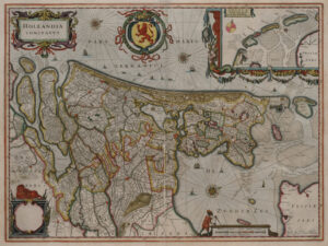
In 1659, the famous mapmaker Joan Blaeu published his world atlas Tooneel des Aardrycks [Display of the Realm of Earth]. The archives in Leiden have made their atlas available online. This week we are looking at his map of the county of Holland. The map shows several lakes have already been turned into polders, such as the Beemster, Purmer, Schermer, and Wormer. The Haarlemmermeer was still a lake. The largest city on the map if Amsterdam, connected to the Zuyder Zee [South Sea, a bay of the … [Read more...]
Map of the Week – Zeeland, 1659
26 August 2024 by Leave a Comment

In 1659, the famous mapmaker Joan Blaeu published his world atlas Tooneel des Aardrycks [Display of the Realm of Earth]. The archives in Leiden have made their atlas available online. This week we are looking at a map of Zeeland. Compared to a modern map, the province had many more islands in 1659. In this period, people were trying to reclaim land from the sea, but floods sometimes inundated whole regions. The map shows many drowned areas that were later reclaimed from the sea again. See the … [Read more...]
Map of the Week – Overijssel, 1659
8 July 2024 by Leave a Comment

In 1659, the famous mapmaker Joan Blaeu published his world atlas Tooneel des Aardrycks [Display of the Realm of Earth]. The archives in Leiden have made their atlas available online. This week we are looking at his map of Overijssel. It shows the IJssel river on the west, which connected the to the North Sea in the north and the Rhine river in the south, bringing prosperity to the area. The area of Twente in the east shows different cities, including Oldenzaal ("Oldenzeel" on the map), where … [Read more...]
Map of the Week: Gouda in 1649
18 March 2024 by Leave a Comment
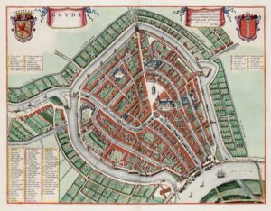
In 1649, one of the most famous mapmakers in the Netherlands, Joan Blaeu published his atlas Tooneel der Steden [approx: Display of Cities]. This map shows Gouda, famous for its cheese market. The entire atlas is online at the Universiteit Utrecht. … [Read more...]

")