Map of the Week – Bodegraven around the church, 1664

Sometimes, maps are created in civil lawsuits, for example in boundary disputes. I love these maps for the details they provide, not just about the location but about the people in the community.

This week we are looking at a map of Bodegraven that shows the houses around the church in 1664. The map was originally part of a law suit, but archivists in the 1800s separated all the maps from the rest of the cases to put in a map collection. That collection of Domestic Maps Hingman has a lot of manuscript maps like this.

Bodegraven map 1664

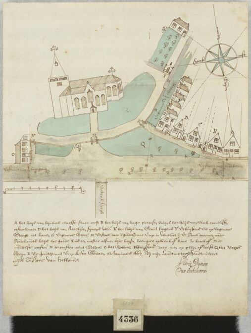
Map of a part of Bodegraven around the church, 1664. Credits: Floris Damen van Oudshoorn, call no. 4336, record group 4.VTH, Nationaal Archief, The Hague (public domain).

About Yvette Hoitink

Yvette Hoitink, MLitt, CG®, QG™ is a professional genealogist, writer, and lecturer in the Netherlands. She has a Master of Letters in Family and Local History from the University of Dundee, and holds the Certification of Genealogist and Qualified Genealogist credentials. Yvette served on the Board of Directors of the Association of Professional Genealogists and won excellence awards for her articles in the National Genealogical Society Quarterly and the Association of Professional Genealogists Quarterly. Yvette has been doing genealogy for over 30 years. She helps people from across the world find their ancestors from the Netherlands and its former colonies, including New Netherland. Read about Yvette's professional genealogy services.

Leave comment

*