Several of you voted for cadastral records as the topic you would like me to write about in 2021, so here we go. This is the first article in a series.
The cadastre was introduced in the Netherlands in 1832. The whole country was divided into cadastral municipalities, which did not always completely overlap with the civil municipalities. Each cadastral municipality was divided into sections, and each section into plots. The combination of cadastral municipality, section letter, and plot number uniquely identifies each piece of real estate in the country.
Maps were created to register the original situation. Minute maps (“minuutplans”) showed the location of the plots in a section. Often, multiple sheets were needed to record all the plots in a section. An overview map (“verzamelplan”) per municipality showed the location of each section and sheet.
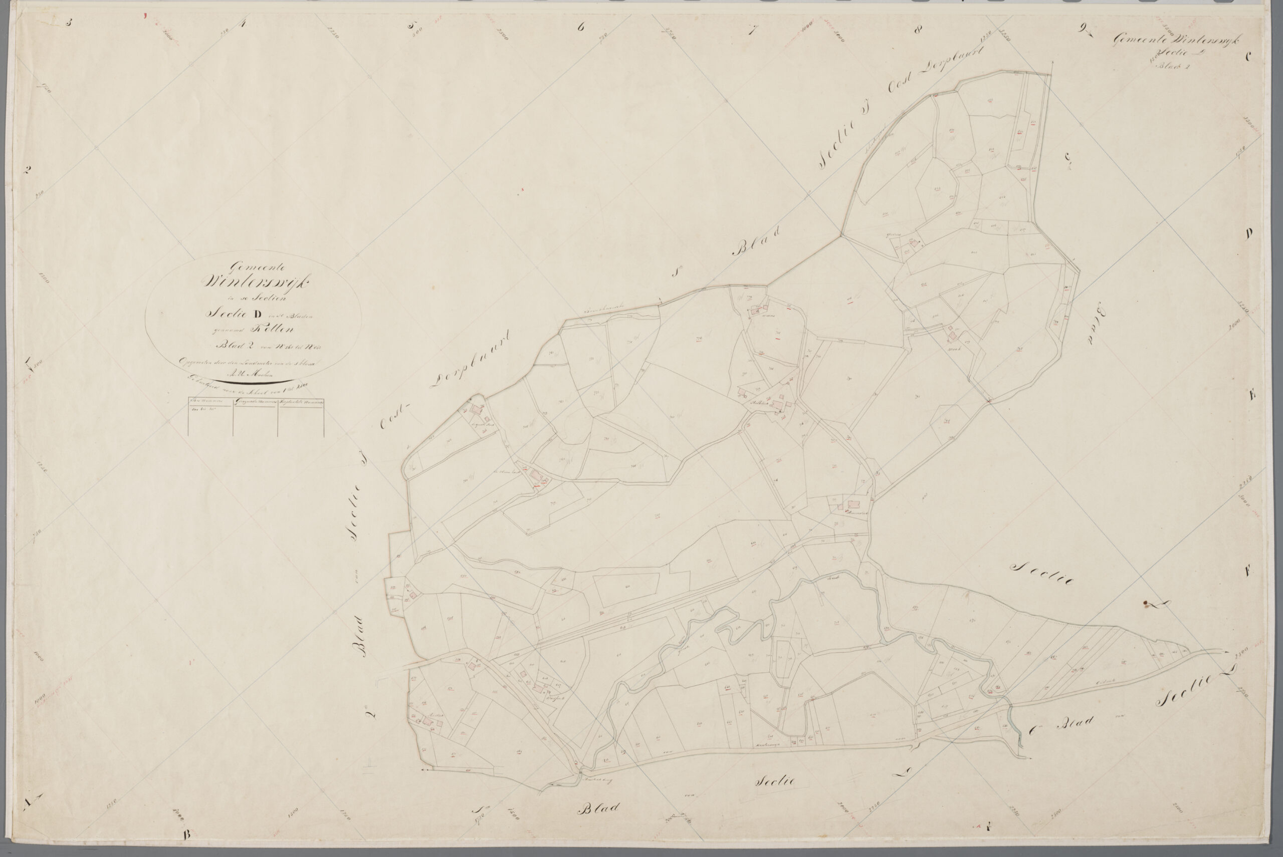
Overview map

Overview map of Winterswijk, 18321
This map shows that the cadastral municipality of Winterswijk was divided into ten sections:
A. Meddeho [Meddo]
B. Huppel
C. Ratum
D. Kotten
E. Woold
F. Miste
G. Corle
H. Westdorpbuurt
I. Oostdorpbuurt
K. Dorp [village]
The letters assigned to these sections do not correspond with the ward letters used in population registers. Nor do the plot numbers correspond with house numbers within these wards.
Minute map
Minute map Winterswijk section D sheet 22
This minute map is the second sheet of section D in Winterswijk. The neighboring sections/sheets are named around the area described in the map.
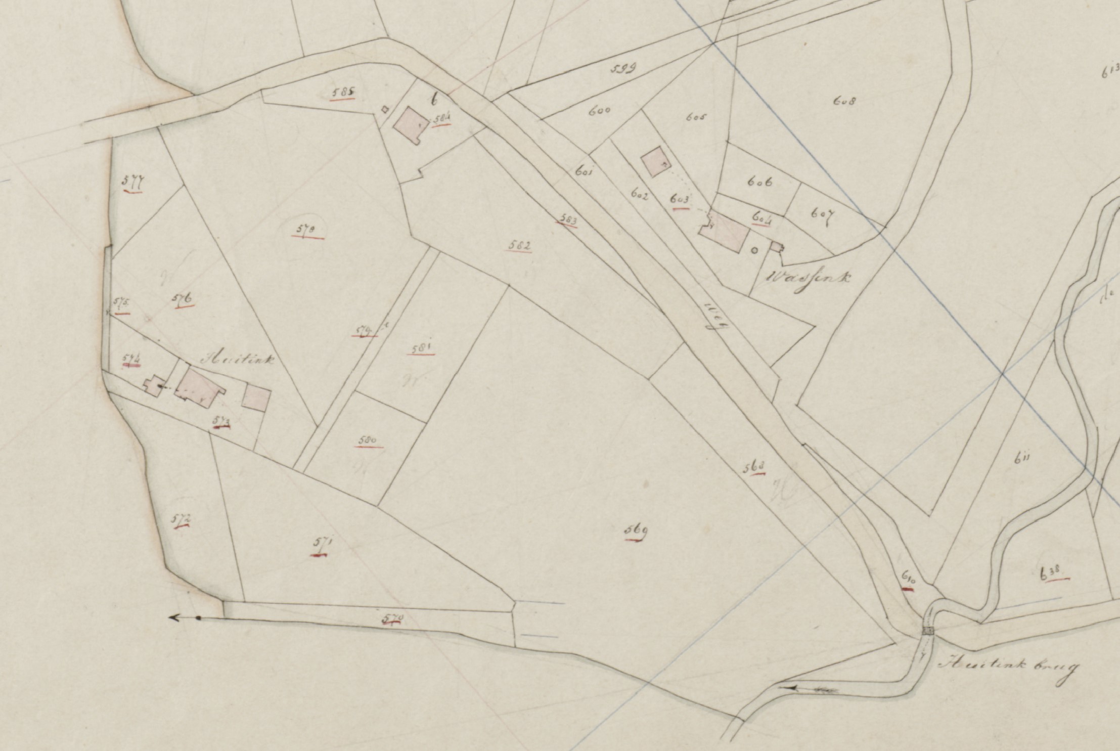
Detail showing Huitink farm
This detail of the minute map shows the location of the Huitink farm that gave my family its name. You can also see the Huitinkbrug, the Huitink bridge, over the Slinge river. Not all cadastral maps include the farm names, but many do in areas where farms had names.
The shows that the farm had plot number Winterswijk D 573. The red color indicates that it is a private building. Public or untaxed buildings, like city halls, schools, and churches, are marked in blue (not in this detail).
One thing to note is that minute maps are often oriented in a way to fit the most information on a page, not necessarily with the north at the top. Somewhere on the map, there will be an arrow or compass to show north. On this D 2 map, the arrow is in the bottom left corn
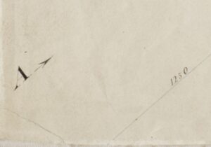
arrow showing north
How to find these maps
The overview maps and image maps of the entire country are available via the Beeldbank Cultureel Erfgoed [image bank of the Cultural Heritage service]:
- Go to the Beeldbank
- Search for the municipality, in this case, Winterswijk
- Filter for Collectie > “Verzamelplans” for the overview maps or “Minuutplans” for the minute maps.
- If you see multiple maps, you can hover over the thumbnails to see the section and sheet number. Click the thumbnail for the map for the detail view.
- The detail view will give you some metadata about the map, including the location on a modern map.
- You can download the map by clicking the download button on the left. They are in the public domain and available for reuse.
For some parts of the Netherlands, the plots on these maps have been entered into a geographical information system and are available via HisGis.
In the next article, we will look at the Original Indicator Tables (“oorspronkelijke aanwijzende tafels”) that show who owned which plot in 1832.
- Cadastral municipality of Winterswijk, overview map, 1832; consulted as “Beeldbank,” digital images, Rijksdienst voor het Cultureel Erfgoed (https://beeldbank.cultureelerfgoed.nl : accessed 31 December 2020), image MIN05175VK1.
- Cadastral municipality of Winterswijk, mianute map, 1832, section D, sheet 2; consulted as “Beeldbank,” digital images, Rijksdienst voor het Cultureel Erfgoed (https://beeldbank.cultureelerfgoed.nl : accessed 31 December 2020), image MIN05175D02.

")
Wonderful post. Using your explanation and the links provided, I was able to locate the “huis en erf” of an ancestor mentioned in the 1830-1839 bevolkingsregister of Slagharen. Looking forward to the next post in the series.
Thank you for this! I was able to find the farm of my ancestor in Oud-Vossemeer.