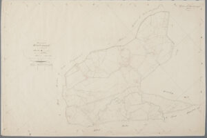
A minuutplan is a type of cadastral map created in 1832 to show the different plots within a section. Most sections were too large to display in one map, so there were often multiple minuutplans per section. See the article about Overview maps and minute maps for more information. … [Read more...]
Dutch term – Oorspronkelijke Aanwijzende Tafel
21 June 2021 by Leave a Comment
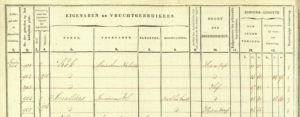
An Oorspronkelijke Aanwijzende Tafel or Original Indicator Table is a ledger of the cadastral administration. It was created in 1832 to show the owners of the plots at that time, when the cadastral administration was introduced. It is organized by municipality and section, and lists all the property owners in that section, or order of plot number. It is commonly abbrevated as OAT. See Cadastre - Original Indicator Table for more information about this source and how to use it. … [Read more...]
Dutch term – Verzamelplan
29 March 2021 by Leave a Comment
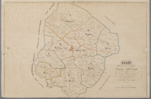
A verzamelplan is a type of cadastral map created in 1832 to show the different sections within a cadastral municipality, and the maps/sheets within each section. See the article about Overview maps and minute maps for more information. … [Read more...]
Cadastre – Original Indicator Tables
12 March 2021 by Leave a Comment
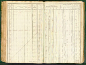
This is the second article in a series about using cadastral records. In the first article, we looked at overview and minute maps that were created when the cadastre was introduced in 1832. These maps show the cadastral municipalities, sections, and plots. This post will show you how to find out who owned each plot. Contents of an original indicator table The oorspronkelijke aanwijzende tafel [original indicator table] recorded the owners of each plot. The tables are organized per … [Read more...]
Cadastre: Overview Maps and Minute Maps
15 January 2021 by 2 Comments
Several of you voted for cadastral records as the topic you would like me to write about in 2021, so here we go. This is the first article in a series. The cadastre was introduced in the Netherlands in 1832. The whole country was divided into cadastral municipalities, which did not always completely overlap with the civil municipalities. Each cadastral municipality was divided into sections, and each section into plots. The combination of cadastral municipality, section letter, and plot … [Read more...]

")