This is the second article in a series about using cadastral records. In the first article, we looked at overview and minute maps that were created when the cadastre was introduced in 1832. These maps show the cadastral municipalities, sections, and plots. This post will show you how to find out who owned each plot.
Contents of an original indicator table
The oorspronkelijke aanwijzende tafel [original indicator table] recorded the owners of each plot. The tables are organized per municipality, per section, and then list all the plots in numerical order.
Original Indicator Table of Winterswijk section D p. 171
The table lists the following information:
- District, village or local name
- Number of the plot
- Owner: name, occupation, place of residence
- Number of the article-based ledger [not always filled in]
- Land use
- Size of the plot
- Class of land
- Tax rate for land, per class
- Tax payable for land and for buildings
Example: Huitink farm in Winterswijk
The minute map showed the Huitink farm in the cadastral municipality of Winterswijk, section D, plot number 573.
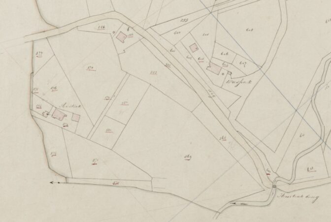
Detail of minute map showing Huitink2
We can browse the original indicator table for section D plot 573.
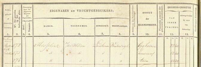
The left side of the register shows that the local name is Huitink, and that plot number 573 was owned by Jan Willem Hesselink, a farmer who lived in Winterswijk. The use of the land was “huis en erf” [house and yard], and the size was 12 “r” [roeden, rods] and 40 “e” [ellen, ells].
We also see the surrounding plots owned by the same owner: plot 572 has “opg. boomen” [growing trees], and plot 574 is a “tuin” [garden]. The previous page has more plots belonging to Jan Willem Hesselink.
The right side shows that the 12r40e size plot belonged to the first class of land, for which a tax of fl. 3.23 was due. Another 18 guilders had to be paid for the house.
How to access these records
The original indicator tables of the entire country are available via the Beeldbank Cultureel Erfgoed [image bank of the Cultural Heritage service]:
- Go to the Beeldbank
- Search for the municipality, in this case, Winterswijk, plus the section letter, in this case D.
- Filter for Collectie > “Oorspronkelijke Aanwijzende Tafels” for the original indicator tables.
- You will see a list of thumbnails. You can hover over to see the description.
- Click a thumbnail to see what plot numbers are listed. If you’re on the wrong page, go back to the overview page and click another thumbnail until you have the right page. There are typically 25 plots per page, so you can estimate the page number and then refine.
- You can download the map by clicking the download button on the left. They are in the public domain and available for reuse.
How to find the plot number
There are several strategies to find out which plots your ancestor owned:
- For some municipalities, the information from the original indicator tables has been indexed in HisGis.
- For some provinces, the information has been indexed in the genealogy search engine at the archives, for example for Zeeland and Friesland. You can check Digital Resources Netherlands and Belgium to see if an online index exists.
- You may find a reference in another record. For example, notarial records and death duties files created after 1832 list the cadastral location of property sold or owned.
- Cadastral atlases have been published in book-form for several municipalities, which list all the owners.
- You may find the plot number in the article-based ledger, to be discussed in the next post in this series.
- You can manually browse the original indicator tables of the place where you think your ancestor may have owned property.
Keep in mind that many people in the Netherlands did not own property, but were tenants or rented their homes.
Note: Civil registration and population registers often list addresses, consisting of a ward letter and a house number. These are not cadastral locations and cannot be used to find cadastral records.
Source
- Cadastral municipality of Winterswijk, original indicator, section D, p. 17, plot 573, 1832; consulted as “Beeldbank,” digital images, Rijksdienst voor het Cultureel Erfgoed (https://beeldbank.cultureelerfgoed.nl : accessed 18 January 2021), image OAT05175D017.
- Cadastral municipality of Winterswijk, minute map, 1832, section D, sheet 2; consulted as “Beeldbank,” digital images, Rijksdienst voor het Cultureel Erfgoed (https://beeldbank.cultureelerfgoed.nl : accessed 31 December 2020), image MIN05175D02.

")