
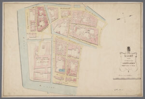
This week's map takes us to Joure in Friesland. The map shows the village of Joure and the nearby Heremastate, a manor house. In Friesland, a state was a manor, typically owned by a patrician or noble family. These families would often buy properties in the area that had voting rights in the provincial assembly, making them more powerful. Even if you do not descend from these families yourself, your Frisian ancestors may have dealt with them as magistrates, employers, or landlords. … [Read more...]
Map of the week – Krimpenerwaard water board, 1792
19 December 2024 by 1 Comment

This map shows the water board of Krimpenerwaard, the area around Schoonhoven, south of Gouda in the current province of South Holland. See the waterschap blog post to learn more about water boards. The map shows the different polders and streams in the water board's district. The map can help you locate ancestral properties if the polder is noted in land records. Note that the map is oriented with the north at the bottom of the map, as you can see in the compass. The vignette shows that … [Read more...]
Map of the Week – Brabant, 1659
9 December 2024 by Leave a Comment

In 1659, the famous mapmaker Joan Blaeu published his world atlas Tooneel des Aardrycks [Display of the Realm of Earth]. The archives in Leiden have made their atlas available online. This map shows the Duchy of Brabant. It is oriented with the north toward the right. You can see that various places that are now part of the province of North Brabant, such as the area around Willemstad and Heusden, were then part of the province of Holland (outlined in pink). The former Duchy of Brabant is now … [Read more...]
Map of the Week – Dikes and Dunes near Petten, 1730
25 November 2024 by Leave a Comment

This week, we are looking at a map of the area south of Petten in the province of Holland (now North-Holland) in 1730. The water board commissioned the map from Jan Spruytenburgh and Hendrik de Leth. The map tells the history of the landscape, and reclaiming the land to create polders. On the left side, we see the smaller polders surrounding by dikes, created in the medieval period. On the right, we see the large polder of the Zijpe, one of the first industrial-scale commercial reclamations, … [Read more...]
Map of the Week – Tourist Map of Drenthe, 1933
11 November 2024 by 1 Comment

This week we are looking at a map of Drenthe in 1933. It is a tourist map from Sleeswijk's pocket atlas for the Netherlands for walkers, bicyclists, and automobile drivers, made in 1933. The whole atlas is available at the website of the National Archives in The Hague. The map shows different kinds of connections: Railroads and tram lines in black Main roads in wide solid orange Brick roads in dotted orange Paved roads in narrow solid orange Unpaved roads in dashed orange … [Read more...]
Map of the Week – Leeuwarden Ward C, 1843
4 November 2024 by Leave a Comment
This week, we are looking at a ward map for Leeuwarden. The map shows buildings in ward C in 1843, with their house numbers. In many places in the nineteenth century, houses were indicated by their ward letters and house numbers. One ward would consist of several streets, so only one street in the ward would have a house number 1, for example. This makes it very hard to translate old addresses to modern addresses. See tips to find the address. Reseachers with ancestors in Leeuwarden in the … [Read more...]
Map of the Week – Ouddorp, 1868
28 October 2024 by Leave a Comment

Between 1865-1868, Jacob Kuyper published a series of atlases with municipal maps. These show the location of all the hamlets, villages, and larger towns in the municipality, as well as the main roads and railroads. The Kuyper maps are often available at the websites of archives or via Wikimedia Commons. This week we are looking at a map of Ouddorp. I know several readers have ancestors from that village, since many people emigrated from Ouddorp in the mid-1800s. The map shows the … [Read more...]
Map of the Week – Holland, 1659
21 October 2024 by Leave a Comment
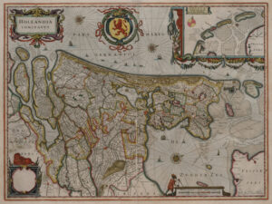
In 1659, the famous mapmaker Joan Blaeu published his world atlas Tooneel des Aardrycks [Display of the Realm of Earth]. The archives in Leiden have made their atlas available online. This week we are looking at his map of the county of Holland. The map shows several lakes have already been turned into polders, such as the Beemster, Purmer, Schermer, and Wormer. The Haarlemmermeer was still a lake. The largest city on the map if Amsterdam, connected to the Zuyder Zee [South Sea, a bay of the … [Read more...]
Map of the Week – Connections in Utrecht, circa 1919
14 October 2024 by Leave a Comment

This map, created shortly after the end of World War I, shows the different connections in the province of Utrecht The legend identifies the different types of lines on the map: railroads tramways paved roads gravel roads provincial border dikes hills. The 1800s saw a tremendous increase in infrastructure. This map captures the rail and tram infrastructure at its height. In the course of the 1900s, many rail and tram lines were abolished as cars and transport by road … [Read more...]
Map of the Week – Overijssel, 1680
7 October 2024 by Leave a Comment

This map of Overijssel was originally created by Nicolaas ten Have and printed by Frederik de Wit in 1680. Such maps can be useful to understand the location where your ancestor lived. It shows the major roads and rivers. It also shows the jurisdictions, in this case the Land van Vollenhove in blue, Salland in yellow, and Twente in pink. The map shows some local features like noble manors, castles, water mills, and quarries. … [Read more...]

")