
Between 1865-1868, Jacob Kuyper published a series of atlases with municipal maps. These show the location of all the hamlets, villages, and larger towns in the municipality, as well as the main roads and railroads. The Kuyper maps are often available at the websites of archives or via Wikimedia Commons. This week we are looking at a map of Ouddorp. I know several readers have ancestors from that village, since many people emigrated from Ouddorp in the mid-1800s. The map shows the … [Read more...]
Map of the Week – Veendam, circa 1868
29 July 2024 by Leave a Comment

Between 1865-1868, Jacob Kuyper published a series of atlases with municipal maps. These show the location of all the hamlets, villages, and larger towns in the municipality, as well as the main roads and railroads. The Kuyper maps are often available at the websites of archives or via Wikimedia Commons. This week we are looking at Veendam, a municipality in Groningen. "Veendam" means "peat dam." The thin rectilinear plots reflects its peat mining history. The area was known for shipbuilding. … [Read more...]
Map of the Week – Goes, 1867
10 June 2024 by Leave a Comment

Between 1865-1868, Jacob Kuyper published a series of atlases with municipal maps. These show the location of all the hamlets, villages, and larger towns in the municipality, as well as the main roads and railroads. The Kuyper maps are often available at the websites of archives or via Wikimedia Commons. This week we are looking at Kuyper's map of Goes, in the province of Zeeland in 1867. It shows that Goes had a railroad connection to Bergen op Zoom and a railway station just south of the … [Read more...]
Map of the Week – Municipality Nederweert, 1866
25 March 2024 by 1 Comment
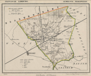
Between 1865-1868, Jacob Kuyper published a series of atlases with municipal maps. These show the location of all the hamlets, villages, and larger towns in the municipality, as well as the main roads and railroads. The Kuyper maps are often available at the websites of archives or via Wikimedia Commons. Here is an example of such a map, showing Nederweert in the province of Limburg in 1866. You can see the village itself was small, and crossed by two canals. The railroad ran through the … [Read more...]

")