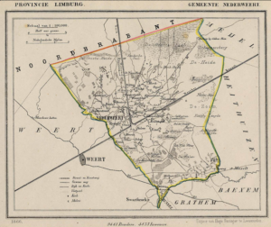
Between 1865-1868, Jacob Kuyper published a series of atlases with municipal maps. These show the location of all the hamlets, villages, and larger towns in the municipality, as well as the main roads and railroads. The Kuyper maps are often available at the websites of archives or via Wikimedia Commons. Here is an example of such a map, showing Nederweert in the province of Limburg in 1866. You can see the village itself was small, and crossed by two canals. The railroad ran through the … [Read more...]

Yvette Hoitink, MLitt, CG®, QG™ is a professional genealogist, writer, and lecturer from the Netherlands who helps people find their ancestors from the Netherlands and its former colonies, including New Netherland. She has a Master of Letters in Family and Local History from the University of Dundee, and holds the Certified Genealogist and Qualified Genealogist credentials.
Do you need a genealogist in the Netherlands to help you with your research?
Please read what Yvette can do for you.
")
This Dutch Genealogy webinar gives you a great introduction to researching your Dutch ancestors. Requires a Legacy FamilyTreeWebinar subscription to watch. [Affiliate link]