In 1891, Cornelis Lely came up with a plan to claim more land from the sea. His ambitious plan involved building a dike between North Holland and Friesland to close off the Zuiderzee [South Sea]. That would make it possible to reclaim large sections of land and create a fresh water lake, the IJsselmeer. This plan formed the basis of a major water engineering project carried out in the first half of the 1900s. In 1932, the dike was completed. The southern (Flevopolder) and eastern (Noordoost polder) areas were turned into land in the 1950s and 1960s. The western polder was never built and is now a nature reserve. In 1986, the Flevopolder and Noordoost polder together formed the new province of Flevoland, the twelfth province of the Netherlands.
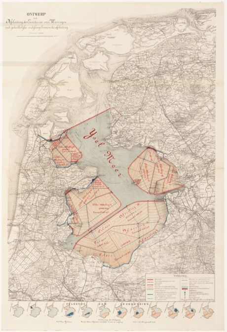
Plan by Cornelis Lely to drain the South Sea, 1891. Credits: Zuiderzeemuseum (public domain)

")
Nice post; great map. One question though:
Did you make a concious decision about translating “Zuiderzee” into “South Sea”?
Not even the Zuiderzeemuseum does that; and South Sea usually refers to the southern part of the Pacific or Oceania.
The referral in Wikipedia reads: “Zuiderzee or Southern Sea, a reclaimed bay of the North Sea, now IJsselmeer, Netherlands”.
Sorry; just my autism playing up again.
I just translated that as opposed to the North Sea. I did not realize that others translated it differently.