This week we are looking at a map that is directly related to my own family tree. It depicts the shooting of my ancestor Tonis Willinck at the border between Winterswijk and Münster. The map dates from around 1590-1595.
This is one of several maps in the collection of the Landesarchiv Nordrhein Westfalen, Germany, just across the border from Winterswijk, that depict the border between Gelderland and Münster. The border ran through a swampy area and was not well-defined in the Middle Ages. Farmers from both sides of the border claimed rights in the commons, to graze their sheep, collect rushes, or even carve out land to start new farms. Over time, more and more border disputes arose, and those disputes led to the creation of records, including maps.
This particular maps, oriented with the east at the top, shows the border between the Dutch hamlet of Ratum (“Raedtman” on the map) and Münster. It depicts various farms, fields, creeks, and other landmarks, including border markers (“merck paal”).
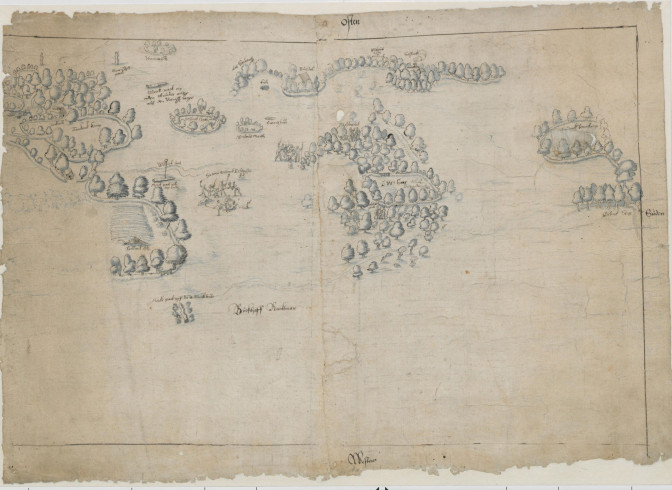
Map of Winterswijk and the neighboring German countryside, about 1590-1595. Collection Landesarchiv NRW Abteilung Westfalen, W 051, Karten A, nr. 3513.
One unusual feature of the map is that it shows various altercations between people. This map was created during the Eighty Years’ War, when soldiers marauded the countryside looking for money or food. One of the altercations shows the shooting of Tonis Willinck near the border marker at Willinck creek. If we look closely, we can see that the attackers wore helmets and carried guns, swords, and maces.
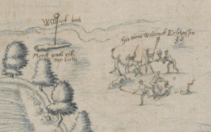
Place where Tonnis Willinck was shot
The map was taken out of its original context and is now part of the map collection of the archives. It made me wonder if it was created as part of a larger trial or civil suit, and whether those records survive. A careful search of the online finding aids uncovered a file about disputes between the heritors of Nichtern in Münster versus those of Bredevoort, with details about the exeution of Tonis Willinck, including interrogations of witnesses, between 1548 and 1579. Since it is unlikely two same-named men were shot in that border area, this must be the same Tonis Willinck as depicted in the map. He must have been shot decades earlier than the estimated date of the map. He may have been one or two generations older and not the ancestor I originally thought. I see a trip to Münster in my future!

")