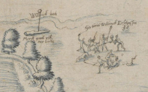
This week we are looking at a map that is directly related to my own family tree. It depicts the shooting of my ancestor Tonis Willinck at the border between Winterswijk and Münster. The map dates from around 1590-1595. This is one of several maps in the collection of the Landesarchiv Nordrhein Westfalen, Germany, just across the border from Winterswijk, that depict the border between Gelderland and Münster. The border ran through a swampy area and was not well-defined in the Middle Ages. … [Read more...]
Map of the Week – Siege of Breda, 1624-1625
6 May 2024 by Leave a Comment

Wars often lead to the creation of maps. This week we are looking at a map of the siege of Breda in 1624-1625. The map shows how Breda had been surrounded by a line, just outside the reach of the city's canon. This allowed the attackers to cut supply lines while they besieged the city. This map is of personal interest to me since several of my ancestors lived in this area. One of them had his land confiscated during the siege to build the bank and ditch and fortlets around Breda. Read more … [Read more...]

")