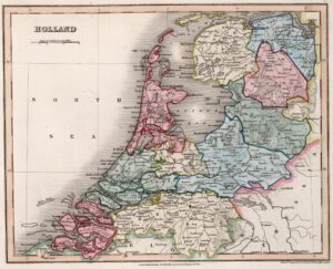
This map of Holland appeared in an English atlas in 1832. This is two years after the Southern Netherlands split off to found the independent country of Belgium in 1830, but seven years before the Dutch government acknowledged the loss of these provinces and recognized Belgium as an independent country in 1839. In other words, we can see from the territory on the map that this 1832 map was not created in the Netherlands, since then it would have had the southern provinces too. The map shows … [Read more...]

Yvette Hoitink, MLitt, CG®, QG™ is a professional genealogist, writer, and lecturer from the Netherlands who helps people find their ancestors from the Netherlands and its former colonies, including New Netherland. She has a Master of Letters in Family and Local History from the University of Dundee, and holds the Certified Genealogist and Qualified Genealogist credentials.
Do you need a genealogist in the Netherlands to help you with your research?
Please read what Yvette can do for you.
")
This Dutch Genealogy webinar gives you a great introduction to researching your Dutch ancestors. Requires a Legacy FamilyTreeWebinar subscription to watch. [Affiliate link]