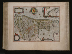
I love to use old maps to see where my ancestors lived. One of the highlights in the history of cartography is the world atlas created by Willem Blaeu in 1662. Erfgoed Leiden, the archives in Leiden, have digitized their Blaeu atlas. You can browse the atlas via Bladeren door Blaeu [Browse Blaeu]. Klik the pink button "Start met Bladeren" to browse the atlas. You can filter by: album [volume] werelddeel [continent] land [country] plaats [town] The names of the geographic … [Read more...]

Yvette Hoitink, MLitt, CG®, QG™ is a professional genealogist, writer, and lecturer from the Netherlands who helps people find their ancestors from the Netherlands and its former colonies, including New Netherland. She has a Master of Letters in Family and Local History from the University of Dundee, and holds the Certified Genealogist and Qualified Genealogist credentials.
Do you need a genealogist in the Netherlands to help you with your research?
Please read what Yvette can do for you.
")
This Dutch Genealogy webinar gives you a great introduction to researching your Dutch ancestors. Requires a Legacy FamilyTreeWebinar subscription to watch. [Affiliate link]