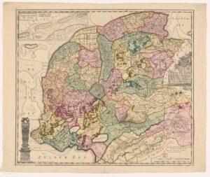
This week, we are looking at a map of Friesland from 1718. In 1682, Bernardus Schotanus à Sterringa was hired to create maps of all the municipalities in Friesland. A second improved version of this series was compiled by François Halma. He added an overview map that showed all the municipalities, shown below. You can consult the maps of individual municipalities on the website Friesland op de Kaart. … [Read more...]

Yvette Hoitink, MLitt, CG®, QG™ is a professional genealogist, writer, and lecturer from the Netherlands who helps people find their ancestors from the Netherlands and its former colonies, including New Netherland. She has a Master of Letters in Family and Local History from the University of Dundee, and holds the Certified Genealogist and Qualified Genealogist credentials.
Do you need a genealogist in the Netherlands to help you with your research?
Please read what Yvette can do for you.
")
This Dutch Genealogy webinar gives you a great introduction to researching your Dutch ancestors. Requires a Legacy FamilyTreeWebinar subscription to watch. [Affiliate link]