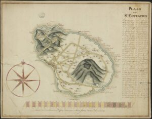
Saint Eustatius in the West Indies is one of the Netherlands Antilles. In the 1700s, it was a colony of the Netherlands. This manuscript maps shows the island in the early 1700s and marks all the plantation owners on the map. The archival description says this map dates from the 18th century. Based on research on the island I recognize several of the names as plantation owners in the early 1700s. Translated legend with abbreviations resolved: A. The Lower Village B. The Upper … [Read more...]
Ask Yvette – Where Can I Find Records For St. Eustatius?
12 October 2018 by 5 Comments
Over the past months, two readers have asked me where to find records for St. Eustatius, an island in the Caribbean. Since more people may have the same question, I thought I'd turn it into an article. St. Eustatius is a special municipality in the Kingdom of the Netherlands. The former Dutch colony is part of the Netherlands Antilles. If you have ancestors from St. Eustatius, here is an overview of the available records. An index to the civil registration birth, marriage, and death … [Read more...]

")