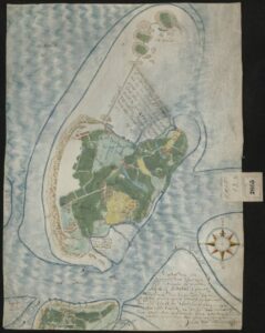
In this new series we will look at a different map every week. We kick off the series with a beautiful manuscript map of the island of Texel from 1645. Many ships departing to New Netherland or other Dutch colonies would lie on the roads of Texel to take in fresh water and wait for favorable winds before crossing the ocean. … [Read more...]

Yvette Hoitink, MLitt, CG®, QG™ is a professional genealogist, writer, and lecturer from the Netherlands who helps people find their ancestors from the Netherlands and its former colonies, including New Netherland. She has a Master of Letters in Family and Local History from the University of Dundee, and holds the Certified Genealogist and Qualified Genealogist credentials.
Do you need a genealogist in the Netherlands to help you with your research?
Please read what Yvette can do for you.
")
This Dutch Genealogy webinar gives you a great introduction to researching your Dutch ancestors. Requires a Legacy FamilyTreeWebinar subscription to watch. [Affiliate link]