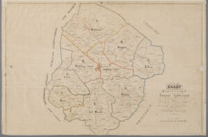
Several of you voted for cadastral records as the topic you would like me to write about in 2021, so here we go. This is the first article in a series. The cadastre was introduced in the Netherlands in 1832. The whole country was divided into cadastral municipalities, which did not always completely overlap with the civil municipalities. Each cadastral municipality was divided into sections, and each section into plots. The combination of cadastral municipality, section letter, and plot … [Read more...]
Cadastre – Original Indicator Tables
12 March 2021 by Leave a Comment
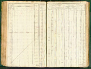
This is the second article in a series about using cadastral records. In the first article, we looked at overview and minute maps that were created when the cadastre was introduced in 1832. These maps show the cadastral municipalities, sections, and plots. This post will show you how to find out who owned each plot. Contents of an original indicator table The oorspronkelijke aanwijzende tafel [original indicator table] recorded the owners of each plot. The tables are organized per … [Read more...]

")