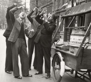
Vrijdag is Dutch for Friday. Traditionally, vrijdag was fish day in the Netherlands, based on the Catholic tradition to abstain from eating meat on Fridays. … [Read more...]
Map of the Week – Gelderland, 1659
19 May 2025 by Leave a Comment
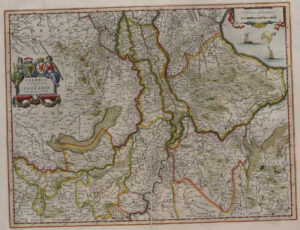
In 1659, the famous mapmaker Joan Blaeu published his world atlas Tooneel des Aardrycks [Display of the Realm of Earth]. The archives in Leiden have made their atlas available online. This week we are looking at Blaeu's map of Gelderland, oriented with the north towards the right. We can see the major rivers Rhine [Rijn in Dutch, "Rhenus fluvius" on the map], Meuse [Maas in Dutch, "Mase fluvius" on the map], Waal ["Waal flu."], and IJssel ["Yssel flu." ]. Most of Gelderland's most prosperous … [Read more...]
8 Ways To Find Your Ancestor’s Emigration Date
16 May 2025 by 1 Comment
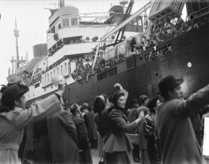
If your ancestors left the Netherlands to move to a different country, you may be wondering when they left. Here are eight strategies and sources to find out their emigration date. 1. Passenger lists Perhaps the passenger list that documented their journey has survived. These can typically be found in the place of arrival. An example are the New York Passenger Lists at Castle Garden, 1820-1891 (FamilySearch). 2. Passage fees records Sometimes, the shipping company kept a separate set of … [Read more...]
Map of the week – Vlissingen, 1750
12 May 2025 by Leave a Comment

This week we are looking at a map of Vlissingen (Flushing) in Zeeland in 1750. The map is part of a series of topographical maps created by Anthonie and David Willem Coutry Hattinga. The Austrian War of Succession (1740-1748), during which the French invaded the southern Netherlands, created a demand for accurate maps of the border area. The Hattinga brothers received a commission to survey the province of Zeeland. The map shows the fortified harbor town of Vlissingen on the island of … [Read more...]
Dutch term – Middenstand
7 May 2025 by Leave a Comment
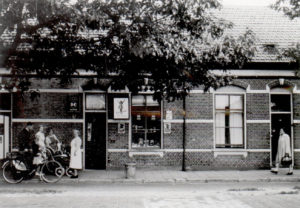
The middenstand is the middle class. Middenstanders are typically self-employed. Historically, most Dutch people who were considered middle class were either business owners or had a trade. Aunt Piet Trouw (in white apron) before her shop in Princenhage (public domain) … [Read more...]
Map of the Week – Doetinchem Destruction in World War II
5 May 2025 by Leave a Comment

This week we are looking at a map of Doetinchem, created between 1946 and 1961. It shows the damage to buildings during World War II. The map was created to inform the plans to rebuild the town center. Red: destroyed Blue: heavy damage Yellow: light damage. Doetinchem was one of several towns in the Netherlands that was bombed during the war. Doetinchem was targeted by allied bombs three times: on 19, 21, and 23 March 1945. 120 buildings in the center were destroyed, and 170 … [Read more...]
Dutch Genealogy News for April 2025
30 April 2025 by Leave a Comment
Here is an overview of all the new sources, websites, and news from archives that came out in the past month. Sources Death Duties Files of Brabant 1903-1927 have been digitized and indexed and can be searched at the Brabants Historisch Informatie Centrum website. Catholic baptisms, marriages, and burials, and marriage duties registers of Hoorn have been indexed and are now available via the West-Fries Archief. Leiden police reports from World War II (1940-1945) can now be consulted … [Read more...]
Map of the Week – Eminent Domain for The Hague, 1913
28 April 2025 by Leave a Comment

This map shows the plans for a new railroad connection for the municipal slaughterhouse in The Hague in 1913. To build the new railroad, several pieces of land had to be acquired by the government via eminent domain. The land in question is marked in brown, future developments of the area in salmon pink, the existing waterways are in light green, and the new waterways in teal. If your ancestors owned land and were dispossessed by the government, this could have left interesting records. You … [Read more...]
Dutch term – Paus
22 April 2025 by Leave a Comment

A paus is a pope. Up until recent decades, about half of the Dutch population, especially in the southern half of the Netherlands, was Catholic. The Netherlands has only ever supplied one pope: pope Adrian VI (1459-1523), who served as pope for 20 months until his death. … [Read more...]
Map of the Week – Graves in Wons, 1831
21 April 2025 by 1 Comment

This week we are looking at a rare type of map, showing the graves in the churchyard of Wons in 1831. Wons is a small village in the west of the province of Friesland. This map was probably created as a result of the 1829 law forbidding burials in churches or the built-up area of a town. The law required each town with a population over 1000 to designate a cemetery outside the town proper. The map shows the locations of the graves around the church, and gives a list of names of owners of … [Read more...]

")