
In the Netherlands, privacy laws restrict access to records of people who may still be alive. But this often affects records of people who were born (much) earlier too. A few examples: Death records are only public after 50 years. My great-grandmother was born in 1893 but her death record only became public this year because she was 80 years old when she died. Notarial records become public after 75 years. If a person born in 1880 makes a will in 1970, their will only becomes public … [Read more...]
About this website
Creating a website like this is a fun activity. There are so many options, so many choices. What do visitors want? What do I want? In this blog I will describe some of the things I encounter in developing and maintaining this website.
Quick tip – Access Restrictions For People Born More Than 100 Years Ago
21 August 2024 by Leave a Comment
Map of the Week – Sewers in Tilburg
19 August 2024 by 1 Comment
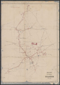
This week we are looking at an often overlooked part of our ancestors' lives: a sewage map. This map shows the network of sewage pipes in Tilburg in 1870. In the 1800s, many municipalities undertook works to improve public health. The cholera outbreak of the 1860s and the discovery of the role of water contamination by raw sewage led to installation of sewage systems all over the country. The Tilburg map shows that by 1870, sewage pipes ran through large parts of the center, though … [Read more...]
Dutch Genealogy News for August 2024
16 August 2024 by Leave a Comment

This is an overview of the new sources, projects, and other news announced this past month. Sources 57 newspapers (almost 155,000 issues) have been added to Delpher, where they can be searched full-text. This includes several local and regional papers, including for Utrecht, Groningen, Zwolle, and Breda. You can search in the latest additions. The Streekarchief Midden-Holland, the archives for the region around Gouda, have digitized several cemetery registers. Municipalities were … [Read more...]
German Genealogy Headquarters
14 August 2024 by Leave a Comment

Great news for people who have German ancestors! My friends Ursula Krause and Ute Brandenburg just founded German Genealogy Headquarters. They can help you with research, mentoring, or education. They are organizing virtual German genealogy symposia. The first one is on Saturday 7 September 2024 with a focus on German History and the Role of the Church in Everyday Life. Registration is now open at a discounted rate. Check their Education page for their plans for the rest of 2024 and 2025. … [Read more...]
Map of the Week – Goeree-Overflakkee over time
5 August 2024 by Leave a Comment

This week we are looking at a map of the island of Goeree-Overflakkee, including two historical maps. The center of the map shows the island as it was in 1842, when the map was created. The island was then called Goedereede en [and] Overflakkee. On the left shows the situation in 1750, when the islands of Goeree and Overflakkee were still seperated at high tide. The right shows the situation around 1300, when the claiming of land had just started. Today, the combined island is part of the … [Read more...]
Quick tip – Look for Employees and Officials
2 August 2024 by Leave a Comment
Records often mention two groups of people: the people who the records are about, and the people who work for the organization that created the records. As genealogists, we often only think about the first category. But we can learn a lot from the records about the employees or officials too. A few examples: Record About Employees or officials Civil registration people who are born, married, or died mayor, aldermen, clerks witnessing records Police … [Read more...]
Map of the Week – Veendam, circa 1868
29 July 2024 by Leave a Comment

Between 1865-1868, Jacob Kuyper published a series of atlases with municipal maps. These show the location of all the hamlets, villages, and larger towns in the municipality, as well as the main roads and railroads. The Kuyper maps are often available at the websites of archives or via Wikimedia Commons. This week we are looking at Veendam, a municipality in Groningen. "Veendam" means "peat dam." The thin rectilinear plots reflects its peat mining history. The area was known for shipbuilding. … [Read more...]
Map of the Week – Children not in School, 1887
22 July 2024 by Leave a Comment
This week we are looking at a thematic map from 1887. It shows the percentage of children between the ages of 6 and 12 who were not in primary school. The statistics were shown per municipality. The darkest blue color represents areas where more than 30% of children did not go to school. A zoomable version is available at Gallica. The map shows great differences between parts of the Netherlands. In general, municipalities in the north had higher school attendance than municipalities in … [Read more...]
How to Convert Old Dutch Weights and Measures
19 July 2024 by 1 Comment
In the Netherlands, the metric system was introduced in 1816. Before that time, different areas used different weights and measures. Not only did they use different terms, but the amount indicated by the term could differ from one place to the next. The Meertens Instituut website has an overview of all the different measures in the country, organized by town, province, or type of measure/weight. If you come across a weight or measure in a record, you can use this website to figure out how … [Read more...]
Map of the Week – Roermond after city fire, 1671
15 July 2024 by Leave a Comment

This week's map is a drawing of the city of Roermond in 1671. It shows the effects of the city fire of 31 May 1665. The houses with the blue roofs were spared, the ones with the red roofs had been destroyed and rebuilt. Fires were a constant threat to our ancestors. In the seventeenth century, many houses were still built with or from wood. Increasingly, cities passed ordinances requiring houses to be built out of brick, or fill the panels between the timber frames with brick, and to use … [Read more...]

")