
This week's map was created in 1656 as part of a conference to settle a boundary dispute between Gelderland and Munster. Around Winterswijk, the border area was covered in moors, and it was unclear where Gelderland ended and Munster started. Farmers from both sides were continuously arguing over who had rights to graze sheep there or collect sods and firewood from those common areas. Nicolaas van Geelkercken was tasked with creating maps showing the border according to Gelderland sources. One … [Read more...]
Map of the Week – Border between Gelderland and Munster near Winterswijk, 1656
27 May 2024 by 3 Comments
The Bizarre Borders of Baarle
18 November 2022 by Leave a Comment
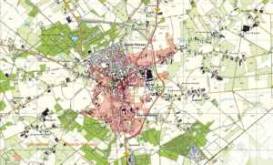
If you look at a modern map of Baarle-Nassau in Noord-Brabant, you will see something weird. Lots of areas are marked in red. These areas are not part of Baarle-Nassau, but of Baarle-Hertog, a municipality in Belgium. There are little bits of Belgium in the Netherlands part, and little bits of the Netherlands in the Belgian part. In total, there are 30 enclaves (territory surrounded by another nation's territory), of which 22 belong to Belgium's Baarle-Hertog (H on the map below) and 8 belong to … [Read more...]
Quick tip – Understanding borders
24 October 2014 by 2 Comments
If your ancestors lived near a border, try to understand the influence it may have had on their lives. At different times, it may have been very easy or very difficult to cross the border. Your ancestors may have been involved in smuggling or border patrol. They may have been called as witnesses to determine where the border was. These activities could have left traces in records. The language spoken on both sides of the border was probably similar, since most people spoke dialect rather … [Read more...]

")