Openbaarheidsbeperking means a limitation on the public availability; an access restriction. You may come across the term in finding aids or archival descriptions. Under the Archiefwet [Archive Law] of 1995, records created by the government are public, and access can only be restricted on three grounds: Privacy of living people, The interests of the real or its allies, Disproportionate disadvantage for another reason. Repositories can also refuse access to original records if … [Read more...]
Map of the week – Border between Rijnland, Utrecht, Amstelland, 1567
8 September 2025 by Leave a Comment
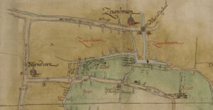
This week we are looking at a map showing the border between Rijnland, Utrecht, and Amstelland in 1567. It was a copy from The map is oriented with the north toward the left. Most of the map shows the border between Rijnland (in green) and the Sticht Utrecht (in yellow). These areas all had their own water boards, managing the dikes in their respective areas. The map shows the towns along the border, and indicates which polders belonged to which jurisdiction. Maps like this can help … [Read more...]
Dutch term – Slop
3 September 2025 by Leave a Comment
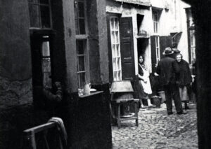
A slop is a slum, a neighborhood with low quality housing. In some cities, like The Hague, the word slop was used for a particular little type of slum, a small alley in between main streets, lined with cheap housing. During the 1800s, many cities grew dramatically. Factories offered jobs, and drew many people from the countryside to the cities. Housing could not keep up with demand, and every little bit of space was used for housing. … [Read more...]
Map of the Week – Railroad Arnhem-Zwolle, 1857
1 September 2025 by Leave a Comment
This week we are looking at a map planning the railroad from Arnhem to Zwolle in 1857. The map shows the planned trajectory and stations. This map can be found in record group 4.WCA at the National Archives, which holds the records for the Department of Public Works and its predecessors 1814-1940. The record group has maps of public works like roads, railroads, dikes, mines, airports, etc. The arrival of a railroad in a town could have affected our ancestors' lives in different … [Read more...]
Dutch Genealogy News for August 2025
29 August 2025 by Leave a Comment
Here is an overview of the new online sources, projects, and other news of the past month. Sources The notarial records of Haarlem and surrounding municipalities 1570-1810 are now full-text searchable. The records have been transcribed using handwritten text recognition, a type of artificial intelligence trained to read Dutch manuscripts. The Westfries Archief is now offering their building plans in their region in an interactive viewer. You have to zoom in to see the markers for houses … [Read more...]
Was Eleanor of Aquitaine my Ancestor? Generation 28 – Marie of France
20 August 2025 by 10 Comments
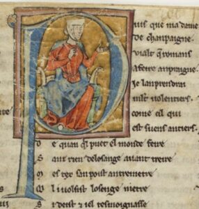
This is the twenty-ninth post in a series about my possible line of descent from Eleanor of Aquitaine. In the first post, I explained how I discovered the possible line, and how I am going to verify it one generation at a time. In the last post, I proved that my twenty-fourth great-grandmother Marie of Champagne, countess of Flanders, was the daughter of Marie of France, countess of Champagne. Biography Marie of France was born in March or April 1145, the daughter of Louis VII of France and … [Read more...]
Dutch term – Fructidor
18 August 2025 by Leave a Comment
Thermidor was the twelfth month in the French Republican calendar, the second month of summer. It started on 18 August (1795-1799) or 19 August (1800-1805). The French Republican calendar was in use in the Netherlands between 1795 and 1813. You may come across the French names of the months in governement records in this period, such as civil registration records. … [Read more...]
Ask Yvette – Difference between Huguenot and Walloon
13 August 2025 by 2 Comments
Several people have asked me what the difference is between a Huguenot and Walloon. Huguenots Huguenots were protestants from France in the 1500s and 1600s. Protestants were persecuted in France from the start of the Reformation in the early 1500s to 1598, when the Edict of Nantes promised them religious freedom, and again after 1685, when the Edict of Nantes was revoked, until 1789, when the French Revolution reintroduced freedom of religion. Many Huguenots went to the northern … [Read more...]
New Netherland (generated) Transcriptions
8 August 2025 by Leave a Comment
I have used handwritten text recognition to automatically transcribe a series of legal records of New Amsterdam, the former name of New York City while under Dutch rule. The records are now full-text searchable via New Netherland Sources. The following records are available: Burgomasters & Schepens, Volume 1: Powers of attorney, acknowledgements, indentures, inventories, deeds and conveyances, March 1653-November 1655 Burgomasters & Schepens, Volume 2: Register of mortgages, … [Read more...]
Dutch Term – Grafsteen
6 August 2025 by Leave a Comment
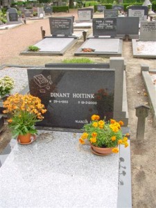
A grafsteen is a gravestone. This is the grave of my uncle Dinant Hoitink, which shows his favorite toy. I wrote about him in my blog post about researching relatives with disabilities. In the Netherlands, graves are routinely cleared after a few decades, so we may usually only be able to find gravestones of more recent ancestors. Whether a grave survives depends on the space the cemetery has. To find a grave, check out these Dutch alternatives to Find a Grave. … [Read more...]

")