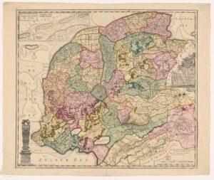
This week, we are looking at a map of Friesland from 1718. In 1682, Bernardus Schotanus à Sterringa was hired to create maps of all the municipalities in Friesland. A second improved version of this series was compiled by François Halma. He added an overview map that showed all the municipalities, shown below. You can consult the maps of individual municipalities on the website Friesland op de Kaart. … [Read more...]
Map of the Week: Texel, circa 1645
26 February 2024 by 1 Comment
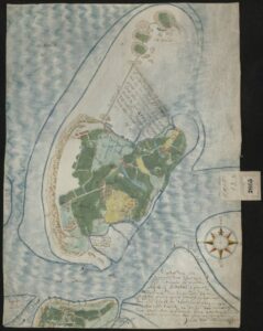
In this new series we will look at a different map every week. We kick off the series with a beautiful manuscript map of the island of Texel from 1645. Many ships departing to New Netherland or other Dutch colonies would lie on the roads of Texel to take in fresh water and wait for favorable winds before crossing the ocean. … [Read more...]

")