
This map shows the Scher-meer [Scher lake, also called Schermermeer], a lake that was drained between 1633 and 1635 to claim land. The map shows how this was done: a dike and ditch were built around the lake. Mills would pump water out of the lake, across the dike, into the surrounding ditch, from where it was carried to rivers and ultimately to the sea. Smaller ditches would criss-cross the lake to drain the land. The mills had to continously pump or the lake would fill up again. The Dutch … [Read more...]
Map of the Week – Siege of Breda, 1624-1625
6 May 2024 by Leave a Comment

Wars often lead to the creation of maps. This week we are looking at a map of the siege of Breda in 1624-1625. The map shows how Breda had been surrounded by a line, just outside the reach of the city's canon. This allowed the attackers to cut supply lines while they besieged the city. This map is of personal interest to me since several of my ancestors lived in this area. One of them had his land confiscated during the siege to build the bank and ditch and fortlets around Breda. Read more … [Read more...]
Map of the week – Holland in 1832
29 April 2024 by Leave a Comment
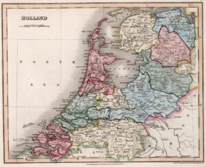
This map of Holland appeared in an English atlas in 1832. This is two years after the Southern Netherlands split off to found the independent country of Belgium in 1830, but seven years before the Dutch government acknowledged the loss of these provinces and recognized Belgium as an independent country in 1839. In other words, we can see from the territory on the map that this 1832 map was not created in the Netherlands, since then it would have had the southern provinces too. The map shows … [Read more...]
Map of the week: Slangenrode farm near Utrecht
22 April 2024 by Leave a Comment
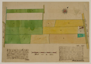
This map shows the Slangenrode farm with its meadows (green) and farmland (green). The farm was located in the Lageweide area between the Huppeldijk and Lageweidsdijk in Utrecht. The map dates from 1718. Although the catalog description does not tell us the purpose of the map, such maps are often created during court cases, for example to settle boundary disputes. You can also sometimes find them as part of estate management records of large landowners, for example map books of all the … [Read more...]
Map of the Week – Bodegraven around the church, 1664
15 April 2024 by Leave a Comment
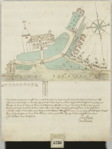
Sometimes, maps are created in civil lawsuits, for example in boundary disputes. I love these maps for the details they provide, not just about the location but about the people in the community. This week we are looking at a map of Bodegraven that shows the houses around the church in 1664. The map was originally part of a law suit, but archivists in the 1800s separated all the maps from the rest of the cases to put in a map collection. That collection of Domestic Maps Hingman has a lot of … [Read more...]
Map of the Week – Map of St. Eustatius, early 1700s
8 April 2024 by 4 Comments
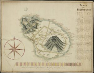
Saint Eustatius in the West Indies is one of the Netherlands Antilles. In the 1700s, it was a colony of the Netherlands. This manuscript maps shows the island in the early 1700s and marks all the plantation owners on the map. The archival description says this map dates from the 18th century. Based on research on the island I recognize several of the names as plantation owners in the early 1700s. Translated legend with abbreviations resolved: A. The Lower Village B. The Upper … [Read more...]
Map of the Week: Brielle circa 1566
1 April 2024 by 3 Comments
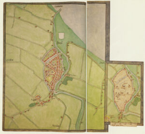
Around 1566, Jacobus van Deventer was charged by the King of Spain and ruler of the Habsburg empire that included the Netherlands to create maps of all the major cities in the country. This was shortly before the outbreak of the Eighty Years War, which started when several noblemen abjured the King as their overlord to form the independent Republic of the United Netherlands. Maps of Jacobus van Deventer can be found in collections of different archives in the Netherlands and Spain. Among the … [Read more...]
Map of the Week – Municipality Nederweert, 1866
25 March 2024 by 1 Comment
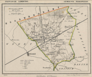
Between 1865-1868, Jacob Kuyper published a series of atlases with municipal maps. These show the location of all the hamlets, villages, and larger towns in the municipality, as well as the main roads and railroads. The Kuyper maps are often available at the websites of archives or via Wikimedia Commons. Here is an example of such a map, showing Nederweert in the province of Limburg in 1866. You can see the village itself was small, and crossed by two canals. The railroad ran through the … [Read more...]
Map of the Week: Gouda in 1649
18 March 2024 by Leave a Comment
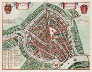
In 1649, one of the most famous mapmakers in the Netherlands, Joan Blaeu published his atlas Tooneel der Steden [approx: Display of Cities]. This map shows Gouda, famous for its cheese market. The entire atlas is online at the Universiteit Utrecht. … [Read more...]
Map of the Week: Minute Map of Bredevoort, 1832
11 March 2024 by 1 Comment
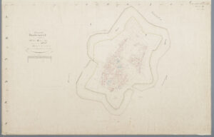
When the cadastral administration was introduced in 1832, maps were made of the entire country. Each municipality was divided into sections. All the plots in a section were mapped in one or more sheets. The map we see today is for Bredevoort, a fortified town in Gelderland. You can find the minute maps for the whole country at the Cultural Heritage Service website or you can read more about cadastral overview maps and minute maps. … [Read more...]

")