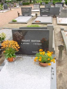
A grafsteen is a gravestone. This is the grave of my uncle Dinant Hoitink, which shows his favorite toy. I wrote about him in my blog post about researching relatives with disabilities. In the Netherlands, graves are routinely cleared after a few decades, so we may usually only be able to find gravestones of more recent ancestors. Whether a grave survives depends on the space the cemetery has. To find a grave, check out these Dutch alternatives to Find a Grave. … [Read more...]
Upcoming Talk – Was Eleanor of Aquitaine my Ancestor?
1 August 2025 by 3 Comments
I will be giving a presentation for Legacy Family Tree Webinars on 20 August 2025: "Was Eleanor of Aquitaine My Ancestor? Applying the GPS across 30 Generations." When I found a line to Eleanor of Aquitaine (1124-1204), Queen of France and England, in online trees, I quickly realized the existing research did not meet standards. I set about verifying the line one generation at a time, to meet the Genealogical Proof Standard. In this presentation, I will take you on my journey, sharing the … [Read more...]
Map of the Week – Local Militias, 1887
28 July 2025 by Leave a Comment

This 1887 map shows the local militias ("schutterijen") for each municipality. Local militias were responsible for the defense of the municipality in case of trouble. Larger municipalities, marked with diagonal red hatching, had active local militias. The men serving in these militias would get regular training and exercises and could be called up at any time to help keep order. Other municipalities had inactive or resting militias. These men were reserves. They could be called up in … [Read more...]
Dutch Genealogy News for July 2025
25 July 2025 by Leave a Comment

Here is an overview of the latest sources, projects, and other news about Dutch genealogy. Sources All notarial records from the city of Utrecht 1560-1811 are now available via the Utrechts Archief. The records have been scanned and indexed. An index of baptisms of Gouda (1719-1736, 1756-1798) is now available via Genealogie Rijnland. An index of orphan chamber records from Woerden 1623-1653 is now available via Genealogie Rijnland. Various transcriptions of tax records from … [Read more...]
Map of the Week – Utrecht, 1659
21 July 2025 by Leave a Comment

In 1659, the famous mapmaker Joan Blaeu published his world atlas Tooneel des Aardrycks [Display of the Realm of Earth]. The archives in Leiden have made their atlas available online. This week we are looking at Blaeu's map of the province of Utrecht. The map shows that its largest city was the same-named Utrecht. The map shows a great difference in geography in the east and west of the province. The east is higher, with more woods. The lower land in the west has been drained and turned into … [Read more...]
Dutch term – Thermidor
18 July 2025 by Leave a Comment
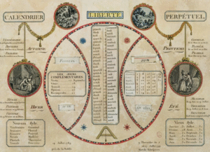
Thermidor was the eleventh month in the French Republican calendar, the second month of summer. It started on 19 July (1795-1799) or 20 July (1800-1805). It was derived from the Greek word θερμός (thermos), meaning heat. The French Republican calendar was in use in the Netherlands between 1795 and 1813. You may come across the French names of the months in governement records in this period, such as civil registration records. … [Read more...]
Map of the week – Confiscated lands in Zutphen, 1573
14 July 2025 by Leave a Comment

This week we are looking at a map showing confiscated lands in Zutphen in 1573. This map was created during the Eighty Years War, when the Netherlands fought to become independent from the Habsburg Empire, ruled by King Philip II of Spain. In 1572, Zutphen was besieged and conquered by Dutch troops, and then by the Spanish. The Spanish seized all the assets of the town, which included several pieces of land in the area. The map shown above shows the location of six pieces of land just … [Read more...]
Dutch term – Publieke Vrouw
10 July 2025 by 1 Comment

Publieke vrouw (literally: public woman) is a term for prostitute you may come across in records in the 1800s and 1900s. For most of this period, prostitution was legal. You may find publieke vrouw as the occupation in population registers or other records, though in many cases, the occupation of such women was left blank. In some cases, it can be inferred from other sources, such as witness statements or hospital records. For more information about researching prostitutes see Looking for … [Read more...]
Map of the week – Land of Daniel Pichot in Suriname
7 July 2025 by Leave a Comment

This 1719 map shows land owned by Daniel Pichot at the Paulus creek in Suriname. The map shows the location of a piece of land, large 1000 acres, at the Paulus creek, a tributary of the Suriname river. The land was surveyed on 25 November 1719 and the map was finished on 13 December 1719. The map showed the three places where the creek entered Pichot's land, ending in a largee swamp. An "Indiaans Dorp" [Native American village" was located on the south-east of the property. The … [Read more...]
Dutch term – Slaaf
1 July 2025 by Leave a Comment
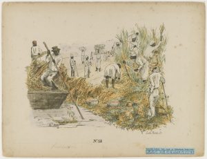
Slaaf is the Dutch word for slave. On 1 July 1863, slavery was abolished in the Dutch colonies of Suriname and the Netherlands Antilles. In practice, the enslaved people were bound to work for their former enslavers for another ten years, to ease the transition. The owners received compensation for the loss of their chattel. The National Archives of the Netherlands has several indexed sources regarding enslaved people, including manumission records. … [Read more...]

")