
This week we are looking at the Topographic-Military Map of 1877, showing the area around Heusden. The map shows traces of the former runs of the river Meuse ("Maas" in Dutch) that meandered through the landscape. Heusden used to be on one bend of the river, before the river found a new course further north. It left behind a part of the bend, called "Doode Maas" [dead Meuse] on the map. If we study the map, we can see several traces of former river bends in the landscape. The changing … [Read more...]
Dutch Genealogy News – June 2025
27 June 2025 by Leave a Comment
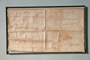
This is an overview of all the new sources, projects, and other news of the past month. Sources Scans of a part of the Aldermen's Court Records of Helmond (1396-1810) are now available via RHC Eindhoven. The remaining records are being uploaded. Birth records of Diessen, Drunen, Eindhoven, Helmond, Mierlo, Nieuwkuijk, Oudheusden, and Riethoven 1923-1924 have been indexed and digitized and can be searched at the Brabants Historisch Informatie Centrum. Transcriptions of the court of … [Read more...]
Map of the Week – Siege of Maastricht, 1748
23 June 2025 by Leave a Comment
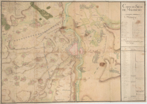
This week we are looking at a map of the siege of Maastricht by the French in 1748. This siege took place during the War of the Austrian Succession. The northern Netherlands did not participate, but the southern Netherlands, including most of Belgium and some parts of the present-day Netherlands, including Maastricht, were involved. The war was fought between Austria, France, and Prussia. The southern Netherland were part of the Habsburg empire, ruled from Austria, and the French … [Read more...]
Dutch Term – Procuratie
20 June 2025 by Leave a Comment
A procuratie is a power of attorney. You may come across procuraties in court or notarial records. Emigrants sometimes gave a procuratie to handle their business in the old country, like buying merchandise, claiming an inheritance, or getting paid for an outstanding debt. … [Read more...]
Dutch term – non-binair, hen, die, diegene
16 June 2025 by Leave a Comment

Since 2018, it has been possible for non-binary people in the Netherlands to have an "X" in their passport instead of "M" (man/male) or "V" (vrouw/female). People have to be at least sixteen years old to choose to register as non-binary. You will not find non-binary people mentioned as such in official records before 2018. Dutch does not have a widely accepted pronouns for non-binary people. Some people prefer "hen," the Dutch version of "they," used with the third person singular verb … [Read more...]
How to Support Genealogy Authors
13 June 2025 by Leave a Comment
We are lucky in the genealogy world to have some great experts that write books: family histories, source editions, how-to books, research guides; you name it. I thought I would share a few ways to support these authors, besides the obvious (buy their books!). Suggest the book to your library or to friends. Write a review for the book, for example on Amazon or GoodReads. Share announcements about books on your social media. Drop them a message if you enjoyed their … [Read more...]
Keynote at New York State Family History Conference
11 June 2025 by Leave a Comment
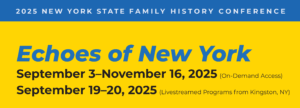
I am honored to have been invited as the keynote speaker for the New York State Family History Conference on 19 September. The conference is organized by the New York Genealogical and Biographical society. This year's theme is Echoes of New York. My keynote address is about "Global Access to Our Shared Heritage." I will be presenting virtually, though the conference has both virtual and in-person options. The early-bird registration is available through 16 June, so if you want to attend, I … [Read more...]
Royal Decrees – Not Just About Important Events
4 June 2025 by Leave a Comment
Royal decrees sound like they would deal with events of national importance. However, in the past, Kings and Queens dealt with many matters of personal importance to their subjects. They may have given dispensation for a marriage, authorized a pension, or naturalized a foreign-born citizen. I am often surprised to learn how many events in the lives of our ancestors went up the government chain of command, all the way to the monarch. See the article about Royal Decrees for more information on … [Read more...]
Map of the Week – Overseas Territories, Early 1800s
2 June 2025 by Leave a Comment
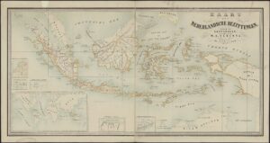
This week we are looking at an undated map from the early 1800s, showing all the overseas possessions claimed by the Netherlands at the time. Click the map to go to the full-size version at the website of the Nationaal Archief. The Dutch East Indies (present-day Indonesia) formed the majority of the Dutch overseas possessions, outlined by ochre yellow. The Netherlands also claimed six islands in the West Indies, land between the Corantijn and Marowijne rivers in South America (present-day … [Read more...]
Dutch Genealogy News for May 2025
30 May 2025 by 2 Comments
Here is an overview of all of the new sources, projects, and other news from the past month. Sources Indexes and scans of birth records of Bathmen (1843-1880), marriage records of Steenwijk (1933-1942), and death records of Denekamp, Diepenheim, Genemuiden, Goor, and Zwollekerspel have been added to Open Archives. Marriage duties of Hoorn 1721-1797 are now available via the Westfries Archief. Vollenhove baptismal records 1697..1761 have been indexed and are available via Van Papier … [Read more...]

")