
This week we are looking at a map of Vlissingen (Flushing) in Zeeland in 1750. The map is part of a series of topographical maps created by Anthonie and David Willem Coutry Hattinga. The Austrian War of Succession (1740-1748), during which the French invaded the southern Netherlands, created a demand for accurate maps of the border area. The Hattinga brothers received a commission to survey the province of Zeeland. The map shows the fortified harbor town of Vlissingen on the island of … [Read more...]
Map of the Week – Doetinchem Destruction in World War II
5 May 2025 by Leave a Comment

This week we are looking at a map of Doetinchem, created between 1946 and 1961. It shows the damage to buildings during World War II. The map was created to inform the plans to rebuild the town center. Red: destroyed Blue: heavy damage Yellow: light damage. Doetinchem was one of several towns in the Netherlands that was bombed during the war. Doetinchem was targeted by allied bombs three times: on 19, 21, and 23 March 1945. 120 buildings in the center were destroyed, and 170 … [Read more...]
Map of the Week – Graves in Wons, 1831
21 April 2025 by 1 Comment

This week we are looking at a rare type of map, showing the graves in the churchyard of Wons in 1831. Wons is a small village in the west of the province of Friesland. This map was probably created as a result of the 1829 law forbidding burials in churches or the built-up area of a town. The law required each town with a population over 1000 to designate a cemetery outside the town proper. The map shows the locations of the graves around the church, and gives a list of names of owners of … [Read more...]
Map of the Week – Shooting of Tonis Willinck, circa 1590
7 April 2025 by Leave a Comment
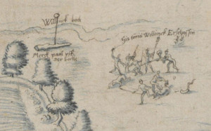
This week we are looking at a map that is directly related to my own family tree. It depicts the shooting of my ancestor Tonis Willinck at the border between Winterswijk and Münster. The map dates from around 1590-1595. This is one of several maps in the collection of the Landesarchiv Nordrhein Westfalen, Germany, just across the border from Winterswijk, that depict the border between Gelderland and Münster. The border ran through a swampy area and was not well-defined in the Middle Ages. … [Read more...]
Map of the Week – Famous Events in the Netherlands
1 April 2025 by Leave a Comment

For April Fools' Day, let's look at a whimsical map. This map of the Netherlands, created in 1930, shows various historical and (then) current events. Highlights include: The light bulb factory in Eindhoven, representing Philips. The reclamation of land in the Zuiderzee. The prison in Veenhuizen. Jan van Schaffelaar jumping from the tower in Barneveld. The fruit orchards in the Betuwe. The invention of herring preservation. Coal mines in southern Limburg. … [Read more...]
Map of the Week – Groningen, 1895
17 March 2025 by 1 Comment

This week, we are looking at a map of the city of Groningen from 1895. The map shows the streets in the center, the cemetery outside the wawlls, and the surrounding countryside. An inset map displays the changes between 1863 and 1888, when the city walls were demolished and new streets created on the southside of the city. Groningen was one of many places in the Netherlands where the old fortifications and town walls were demolished in the second half of the nineteenth century. Improvements … [Read more...]
Map of the Week – Limburg, 1659
10 March 2025 by Leave a Comment

In 1659, the famous mapmaker Joan Blaeu published his world atlas Tooneel des Aardrycks [Display of the Realm of Earth]. The archives in Leiden have made their atlas available online. This week we are looking at Blaeu's map of the Duchy of Limburg. In the east, we can see the river Meuse [Maas in Dutch, "Mosa Fluvius" on the map] connecting the cities of Maastricht ("Maestricht") and Luik ("Luyck vel Liege"). Limburg is in the higher part of the Netherlands, so we see more woods and hills, … [Read more...]
Map of the Week – Groningen, 1659
3 February 2025 by Leave a Comment

In 1659, the famous mapmaker Joan Blaeu published his world atlas Tooneel des Aardrycks [Display of the Realm of Earth]. The archives in Leiden have made their atlas available online. This week we are looking at Blaeu's map of the province of Groningen. It shows its largest city as the same-named Groningen ("Gronningen" on the map), connected to the North Sea by the Reitdiep. The map shows the roads and rivers that connected the smaller towns. See the research guide for Groningen for more … [Read more...]
Map of the Week – World War I map
13 January 2025 by Leave a Comment

This week's map dates from World War I and is part of a larger series showing military activity. This particular map shows the activity until 7 October 1914. The Netherlands was neutral during World War I, as shown by the green color on the map. The map shows how close the activity got, with a sunken U-boat off the coast of Scheveningen, and various battles just across the border in Belgium. Although the Netherlands did not participate in the war, it did affect the lives of Dutch … [Read more...]
Map of the Week – Nautical Chart of the Zeeland and Holland Coast
6 January 2025 by Leave a Comment

This week we are looking at a nautical chart made by Pieter Goos from an atlas published between 1666 and 1683. It shows the access routes to the South Holland and Zeeland rivers and cities. The chart was intended for sailors to set their course. It is oriented with the north on the left, as you can see in the compass. The different compass points allowed navigators to determine the headings to navigate the waters. The chart also showed the depths and channels to take to safely make it to … [Read more...]

")