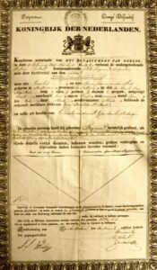
Here is a list of abbreviations you may find in published genealogies in the Netherlands. Abbreviation Full version Translation geb. geboren born ged. gedoopt baptized overl. overleden died begr. begraven buried tr. trouwt marries ondertr. ondertrouwt marriage banns ca. circa circa waarsch. waarschijnlijk probably zn. van zoon van son of dr. van dochter van daughter of wed. van weduwe van widow … [Read more...]
About Yvette Hoitink
Yvette Hoitink, CG®, QG™ is a professional genealogist in the Netherlands. She holds the Certified Genealogist credential from the Board for Certification of Genealogists and has a post-graduate diploma in Family and Local History from the University of Dundee. She has been doing genealogy for over 30 years and helps people from across the world find their ancestors in the Netherlands. Read about Yvette's professional genealogy services.
Map of the week – Holland in 1832
29 April 2024 by Leave a Comment
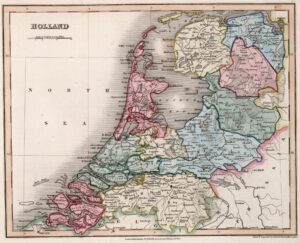
This map of Holland appeared in an English atlas in 1832. This is two years after the Southern Netherlands split off to found the independent country of Belgium in 1830, but seven years before the Dutch government acknowledged the loss of these provinces and recognized Belgium as an independent country in 1839. In other words, we can see from the territory on the map that this 1832 map was not created in the Netherlands, since then it would have had the southern provinces too. The map shows … [Read more...]
Ask Yvette – How do I find all the children?
26 April 2024 by Leave a Comment
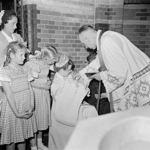
A reader asked me how to find all the children of an ancestral couple. The strategies and sources depend on the period. 1600s, 1700s Sources: Search baptismal, marriage, and burial records to find the baptisms, marriages, and burials of all the children. If one of the parents died before the youngest child was 25, check for guardianship appointments and accounts. Check estate inventories or estate divisions of the parents and grandparents to see which children and grandchildren … [Read more...]
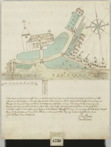
Map of the week: Slangenrode farm near Utrecht
22 April 2024 by Leave a Comment
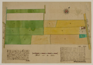
This map shows the Slangenrode farm with its meadows (green) and farmland (green). The farm was located in the Lageweide area between the Huppeldijk and Lageweidsdijk in Utrecht. The map dates from 1718. Although the catalog description does not tell us the purpose of the map, such maps are often created during court cases, for example to settle boundary disputes. You can also sometimes find them as part of estate management records of large landowners, for example map books of all the … [Read more...]
Dutch term – Gepasporteerd
17 April 2024 by 2 Comments
Gepasporteerd (literally: passported) means a passport was issued. You will typically come across the term in military service records in the 1800s. At the end of service, a soldier received a passport to show he fulfilled his military duties. Since these passports were given to the soldiers, they may have survived in private collections but are unlikely to turn up in archives. See the reader question about military passports in the 1800s for an example. … [Read more...]
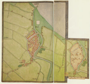
Map of the Week – Bodegraven around the church, 1664
15 April 2024 by Leave a Comment
Sometimes, maps are created in civil lawsuits, for example in boundary disputes. I love these maps for the details they provide, not just about the location but about the people in the community. This week we are looking at a map of Bodegraven that shows the houses around the church in 1664. The map was originally part of a law suit, but archivists in the 1800s separated all the maps from the rest of the cases to put in a map collection. That collection of Domestic Maps Hingman has a lot of … [Read more...]
Dutch Genealogy News for April 2024
12 April 2024 by Leave a Comment
Here is an overview of the new sources, projects, and other news from the past month. Sources The stories of 2100 Engelandvaarders [England sailors] are now available at the National Archives website. Engelandvaarders were Dutch citizens who went to the United Kingdom during World War II, where they were debriefed by British and Dutch security services. The interrogation reports are now online at the website of the National Archives. Petitions to the parliament of the Batavian Republic … [Read more...]
Map of the Week – Map of St. Eustatius, early 1700s
8 April 2024 by 1 Comment
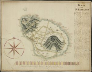
Saint Eustatius in the West Indies is one of the Netherlands Antilles. In the 1700s, it was a colony of the Netherlands. This manuscript maps shows the island in the early 1700s and marks all the plantation owners on the map. The archival description says this map dates from the 18th century. Based on research on the island I recognize several of the names as plantation owners in the early 1700s. Translated legend with abbreviations resolved: A. The Lower Village B. The Upper … [Read more...]
Dutch term – Ploeg, ploegen
3 April 2024 by Leave a Comment
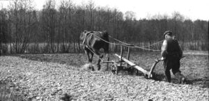
A ploeg (plural: ploegen) is a plow. Ploegen is also the verb "to plow." Plowing was typically done in the spring. You may come across the noun in estate inventories of farmers. … [Read more...]
Map of the Week: Brielle circa 1566
1 April 2024 by 3 Comments
Around 1566, Jacobus van Deventer was charged by the King of Spain and ruler of the Habsburg empire that included the Netherlands to create maps of all the major cities in the country. This was shortly before the outbreak of the Eighty Years War, which started when several noblemen abjured the King as their overlord to form the independent Republic of the United Netherlands. Maps of Jacobus van Deventer can be found in collections of different archives in the Netherlands and Spain. Among the … [Read more...]

")