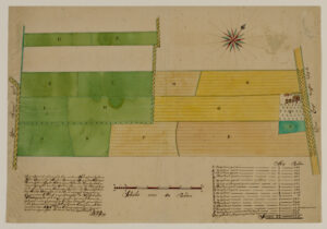
This map shows the Slangenrode farm with its meadows (green) and farmland (green). The farm was located in the Lageweide area between the Huppeldijk and Lageweidsdijk in Utrecht. The map dates from 1718. Although the catalog description does not tell us the purpose of the map, such maps are often created during court cases, for example to settle boundary disputes. You can also sometimes find them as part of estate management records of large landowners, for example map books of all the … [Read more...]
About this website
Creating a website like this is a fun activity. There are so many options, so many choices. What do visitors want? What do I want? In this blog I will describe some of the things I encounter in developing and maintaining this website.
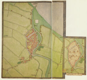
Map of the Week – Bodegraven around the church, 1664
15 April 2024 by Leave a Comment
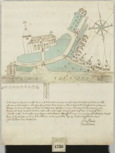
Sometimes, maps are created in civil lawsuits, for example in boundary disputes. I love these maps for the details they provide, not just about the location but about the people in the community. This week we are looking at a map of Bodegraven that shows the houses around the church in 1664. The map was originally part of a law suit, but archivists in the 1800s separated all the maps from the rest of the cases to put in a map collection. That collection of Domestic Maps Hingman has a lot of … [Read more...]
Dutch Genealogy News for April 2024
12 April 2024 by Leave a Comment
Here is an overview of the new sources, projects, and other news from the past month. Sources The stories of 2100 Engelandvaarders [England sailors] are now available at the National Archives website. Engelandvaarders were Dutch citizens who went to the United Kingdom during World War II, where they were debriefed by British and Dutch security services. The interrogation reports are now online at the website of the National Archives. Petitions to the parliament of the Batavian Republic … [Read more...]
Map of the Week – Map of St. Eustatius, early 1700s
8 April 2024 by 1 Comment
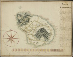
Saint Eustatius in the West Indies is one of the Netherlands Antilles. In the 1700s, it was a colony of the Netherlands. This manuscript maps shows the island in the early 1700s and marks all the plantation owners on the map. The archival description says this map dates from the 18th century. Based on research on the island I recognize several of the names as plantation owners in the early 1700s. Translated legend with abbreviations resolved: A. The Lower Village B. The Upper … [Read more...]
Map of the Week: Brielle circa 1566
1 April 2024 by 3 Comments
Around 1566, Jacobus van Deventer was charged by the King of Spain and ruler of the Habsburg empire that included the Netherlands to create maps of all the major cities in the country. This was shortly before the outbreak of the Eighty Years War, which started when several noblemen abjured the King as their overlord to form the independent Republic of the United Netherlands. Maps of Jacobus van Deventer can be found in collections of different archives in the Netherlands and Spain. Among the … [Read more...]
Quick tip – Who was your ancestor the guardian for?
27 March 2024 by Leave a Comment
I have written before about using guardianship records for genealogical research. Most often, we use these records to find out who became the guardian over minor children after our ancestors died. Less often, we will check those records to see for whom our ancestors were guardians. Since guardians were often close relatives, this can be a clue about the ancestor's family. If guardianships are indexed, that is usually by the (deceaded) parents only, not by guardian, so this may require turning … [Read more...]
Map of the Week – Municipality Nederweert, 1866
25 March 2024 by 1 Comment
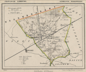
Between 1865-1868, Jacob Kuyper published a series of atlases with municipal maps. These show the location of all the hamlets, villages, and larger towns in the municipality, as well as the main roads and railroads. The Kuyper maps are often available at the websites of archives or via Wikimedia Commons. Here is an example of such a map, showing Nederweert in the province of Limburg in 1866. You can see the village itself was small, and crossed by two canals. The railroad ran through the … [Read more...]
Was Eleanor of Aquitaine my Ancestor? Generation 27 – Marie of Champagne
22 March 2024 by 3 Comments
This is the twenty-eighth post in a series about my possible line of descent from Eleanor of Aquitaine. In the first post, I explained how I discovered the possible line, and how I am going to verify it one generation at a time. In the last post, I proved that my twenty-third great-grandmother Margaret, countess of Flanders, was the daughter of Marie of Champagne, countess of Flanders. Biography Marie of Champagne was born in the spring of 1171 as the second daughter of Henry, count of … [Read more...]
Map of the Week: Gouda in 1649
18 March 2024 by Leave a Comment
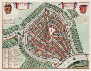
In 1649, one of the most famous mapmakers in the Netherlands, Joan Blaeu published his atlas Tooneel der Steden [approx: Display of Cities]. This map shows Gouda, famous for its cheese market. The entire atlas is online at the Universiteit Utrecht. … [Read more...]
Map of the Week: Minute Map of Bredevoort, 1832
11 March 2024 by 1 Comment
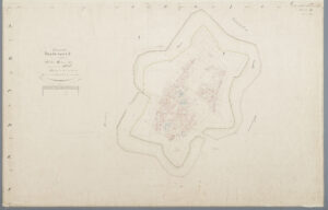
When the cadastral administration was introduced in 1832, maps were made of the entire country. Each municipality was divided into sections. All the plots in a section were mapped in one or more sheets. The map we see today is for Bredevoort, a fortified town in Gelderland. You can find the minute maps for the whole country at the Cultural Heritage Service website or you can read more about cadastral overview maps and minute maps. … [Read more...]

")